


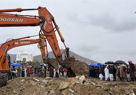
After Nepal quake, India may be next: Experts
Mon 27 Apr 2015
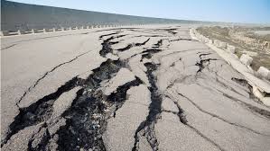
New Delhi: In the wake of the strong 7.9 magnitude earthquake that killed over a 1,500 people in Nepal and left a swathe of devastation in the northern Himalayas on Saturday, experts said a temblor of equal intensity is "overdue" in northern India."
"An earthquake of the same magnitude is overdue. That may happen either today or 50 years from now... in the region of the Kashmir, Himachal, Punjab and Uttrakhand Himalyas. Seismic gaps have been identified in these regions," B.K. Rastogi, the director general of the Ahmedabad-based Institute of Seismological Research, told IANS on the phone.
This is because the movement of tectonic plates generates stress over time, and rocks at the surface break in response. When the stress accumulates, every 100 km stretch of the 2,000-km-long Himalyas can be hit by a high-magnitude earthquake.
"The accumulation of stress is going on everywhere. But where it will reach the elastic limit, we don't know nor also when. But what we do know is that it is happening everywhere," Rastogi added. "With 20 such locations that are prone to high-intensity earthquakes, it takes 200 years for an earthquake of this magnitude to happen on this belt. In 1833, the same epicentre - 80 km northwest of Kathmandu - an earthquake of 7.5 magnitude had hit the region," he said.
According to the India Meteorological Department (IMD), Saturday's quake, measuring 6 on the Richter scale in Delhi, had a depth of 10 km and its impact lasted up to one minute.
The US Geological Survey said the epicentre was in Nepal's Lamjung district some 75 km from Kathmandu. The aftershocks were felt even half-an-hour after the quake and some lasted till evening. Rastogi said that the earthquake uplifted the rocks by four meters, rupturing an area 100 km long and 50 meters wide of the epicentre.
Scientist P.R. Vaidya at IMD here, said Nepal falls on
the Alpine-Himalayan belt, one among the three seismic belts on the Earth's surface, which is responsible for 10 percent of the world's earthquakes.
the Alpine-Himalayan belt, one among the three seismic belts on the Earth's surface, which is responsible for 10 percent of the world's earthquakes.
The Apline-Himalayn belt, which is prone to high-intensity earthquakes, runs through New Zealand, Australia, Indonesia, the Andaman and Nicobar Islands and northeast India, from where it turns to Nepal and then to Jammu and Kashmir, up to Afghanistan and the Mediterranean Sea. It finally ends in Europe.
The world's greatest earthquake belt, the circum-Pacific seismic belt, is found along the rim of the Pacific Ocean, where about 80 percent of the world's largest temblors occur. Rastogi said within the 40-km-range of the epicentre, the scale of damage has been very high, with a total collapse of buildings.
The aftershocks, he added, would be felt for two days in case of a "strong" earthquake" of about magnitude 8.
"Even small buildings that were hit in the first wave may be damaged by the aftershocks if not designed properly. And the aftershocks may continue for one or two months," he said.
About 40 million years ago, India was 5,000 km south of where the Himalyas now stand. With the continental shift, India and the Asian continent came closer to form the Himalayas.
"And the process of movement continues at about two cm every year. The Indian landmass today is pushing the Asian landmass and that generates stress," Rastogi said.
Scientist Vaidya said: "Earthquakes happen because of the theory of plate tectonics, which means with the movement of tactonic plates, stress in generated in the rocks."
The quake claimed nearly 40 lives in India, causing widespread destruction in parts of Bihar, Uttar Pradesh and West Bengal.Earthquakes, however don't kill, said Vaidya. "It's the damage caused to the structures around us that cause the loss of life."
No Comments For This Post, Be first to write a Comment.
Most viewed from Specials


Most viewed from World


Todays Epaper

English Weekly


AIMIM News


Latest Urdu News
Most Viewed
May 26, 2020
Which cricket team is your favourite to win the T20 World Cup 2026?
Latest Videos View All
.jpg)
.jpg)
.jpg)


Like Us
Home
About Us
Advertise With Us
All Polls
Epaper Archives
Privacy Policy
Contact Us
Download Etemaad App
© 2026 Etemaad Daily News, All Rights Reserved.