




Cyclone Akvan May Enter Odisha After Andhra Landfall alert on 4 Districts.
Wed 18 Nov 2026, 13:12:18
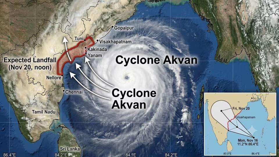
Odisha could face the impact of Cyclone Akvan after it makes landfall along the Andhra Pradesh coast on November 20, with the India Meteorological Department (IMD) revising its forecast to indicate a possible north-northwestward movement into southern parts of the state.
The latest projected trajectory places Malkangiri, Koraput, Nabarangpur and Nuapada districts within the potential impact zone, raising concerns over heavy rainfall and strong winds in southern Odisha.
In a significant revision to its earlier assessment, the IMD has indicated that the system may retain severe cyclonic storm intensity while moving inland, rather than weakening into a deep depression before entering Odisha.
According to the revised
forecast, the cyclone is likely to cross the Andhra Pradesh coast between Nellore and Tuni around noon on November 20, with sustained wind speeds of 120-130 kmph and gusts reaching 145 kmph.
forecast, the cyclone is likely to cross the Andhra Pradesh coast between Nellore and Tuni around noon on November 20, with sustained wind speeds of 120-130 kmph and gusts reaching 145 kmph.
It was located approximately 590 km east of Chennai, 620 km southeast of Machilipatnam, 620 km south-southeast of Visakhapatnam and 750 km south of Gopalpur.
The revised trajectory suggests that after crossing the Andhra Pradesh coast, the system could move north-northwestwards towards southern Odisha, bringing adverse weather conditions to several districts.
Malkangiri, given its geographical proximity to the projected inland route, could be particularly vulnerable. Koraput, Nabarangpur and Nuapada may also experience the impact of the system.
No Comments For This Post, Be first to write a Comment.
Most viewed from National







Most viewed from World








Todays Epaper

English Weekly

AIMIM News





Latest Urdu News
Most Viewed
Aug 02, 2026
Should the government impose stricter measures to control air pollution in Indian cities?
Like Us
Home
About Us
Advertise With Us
All Polls
Epaper Archives
Privacy Policy
Contact Us
Download Etemaad App
© 2026 Etemaad Daily News, All Rights Reserved.