Cyclonic Storm YAAS Likely to intensify into Very Severe Cyclonic Storm in Next 12 Hours
Tue 25 May 2021, 15:37:59
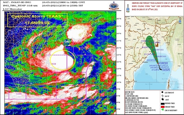
The Severe Cyclonic Storm "Yaas" over East-central Bay of Bengal moved northwestwards with a speed of about 10 kmph during the past 6 hours, and lay centred early today over East-central and adjoining West-central Bay of Bengal near latitude 18.0°N and longitude 88.6°E. It lay about 320 km south-southeast of Paradip (Odisha), 430 km south-southeast of Balasore (Odisha), 420 km south-southeast of Digha (West Bengal) and 470 kms south-southwest of Khepupara (Bangladesh). It is very likely to move north-northwestwards and intensify further into a Very Severe Cyclonic Storm during the next 12 hours.
It would continue to move north-northwestwards, intensify further and reach Northwest Bay of Bengal near north Odisha and West Bengal coasts very close to Chandbali-Dhamra port by the early morning tomorrow. It is very likely to cross north Odisha-West Bengal coasts between Paradip and Sagar Island around Balasore, by tomorrow noon as a Very Severe Cyclonic Storm.
The severe cyclonic storm YAAS over the Bay of Bengal may intensify further into a very severe cyclonic storm today. According to the Indian Meteorological department, Yaas will cross north Odisha coast between Dhamra and Balasore by noon tomorrow as a very severe cyclonic storm with wind speed from 155 to 165 kms per
hour gusting up to 185 kms per hour. Due to the cyclonic impact, several parts of Odisha have been experiencing wind and rainfall of varying degrees. The weather department has issued red for heavy to very heavy and extremely heavy rainfall for the four highly vulnerable districts like Bhadrak, Balasore, Jagatsinghpur and Kendrapada. Meanwhile the Odisha government is fully prepared to mitigate the impact of the cyclone. A number of rescue, relief and restoration teams have been deployed in the high-impact zone. The state government has cancelled all leaves of its employees and holidays till the end of this month.
hour gusting up to 185 kms per hour. Due to the cyclonic impact, several parts of Odisha have been experiencing wind and rainfall of varying degrees. The weather department has issued red for heavy to very heavy and extremely heavy rainfall for the four highly vulnerable districts like Bhadrak, Balasore, Jagatsinghpur and Kendrapada. Meanwhile the Odisha government is fully prepared to mitigate the impact of the cyclone. A number of rescue, relief and restoration teams have been deployed in the high-impact zone. The state government has cancelled all leaves of its employees and holidays till the end of this month.
AIR correspondent reports that till 10 in the morning today, about 50 to 60 thousand people from the low lying and storm surge areas and also from vulnerable pockets have been evacuated to the cyclone shelters. Informing the media today in Bhubaneswar, Pradip Kumar Jena, Special Relief Commissioner of the state said that all the concerned district administration have been asked to complete the evacuation process by today evening.
He said, a total of about 6 thousand 9 hundred cyclone and alternative shelters have been readied in the cyclone-prone areas that can accommodate upto 7.5 lakh people. He said, besides the four high impact districts, local administration of many other districts have also been ed to make arrangements for people for safe shelters in view of the high velocity wind that may blow across in their respective areas as well.
Based on the meteorological inputs, he said that both wind and rainfall, especially in and around the areas likely to take the cyclonic blow, may start gaining in speed and intensity from afternoon today. Mr. Jena said that the government has kept a large number of teams ready to help restore essential services like drinking water, electricity and road connectivity in the cyclonic aftermath. He however has appealed to people of the areas likely to be impacted most to store sufficient water so as to last for at least two to three days as a preparatory measure.
No Comments For This Post, Be first to write a Comment.
Most viewed from International
Most viewed from World
AIMIM News
Latest Urdu News
Most Viewed
May 26, 2020
Which cricket team is your favourite to win the T20 World Cup 2026?
Latest Videos View All
Like Us
Home
About Us
Advertise With Us
All Polls
Epaper Archives
Privacy Policy
Contact Us
Download Etemaad App
© 2026 Etemaad Daily News, All Rights Reserved.













.jpg)
.jpg)
.jpg)


