


Low-pressure is predicted, heavy rains likely across Telangana
Sat 10 Jul 2021, 08:50:23
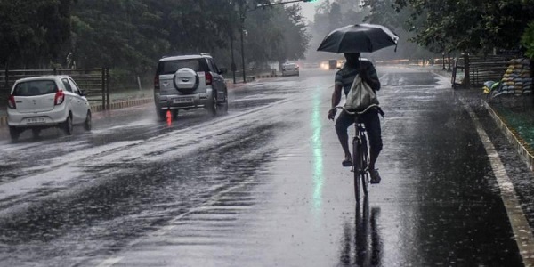
A low-pressure zone is predicted to develop over Odisha and Andhra Pradesh by July 11. Under its influence the state is expected to receive heavy to very heavy rainfall. Monsoon activity is expected to gain steam on account of the formation of cyclonic circulation and low-pressure area over the Bay of Bengal.
"This cyclonic circulation comes coupled with a trough extending across Odisha, Chhattisgarh, and Telangana, which would be followed up with a fresh low-pressure area forming over Northwest Bay of Bengal, off South Odisha and North Andhra Pradesh coast," said a weather bulletin by Indian Meteorological Department
(IMD).
(IMD).
'July and August are the rainiest months for Hyderabad with normal rainfall of 179.2mm and 207mm respectively. Telangana has received a surplus of 45 per cent rainfall so far in this season and the week ending June 30 recorded an excess of 33 per cent. Hyderabad has received 17 per cent above normal rainfall so far,' said a report by the private weather forecaster Skymet.
'A relatively poor start in July is likely to be compensated by the July 7 to 14 wet spell. Heavy rains are expected in some parts in the next 24 hours and followed up with a peak spell between July 11 and 14,' Skymet said.
No Comments For This Post, Be first to write a Comment.
Most viewed from Hyderabad


.jpg)


Most viewed from World


Todays Epaper

English Weekly


AIMIM News


Latest Urdu News
Most Viewed
May 26, 2020
Which cricket teams will reach the IPL 2026 finals?
Latest Videos View All
.jpg)
.jpg)
.jpg)


Like Us
Home
About Us
Advertise With Us
All Polls
Epaper Archives
Privacy Policy
Contact Us
Download Etemaad App
© 2026 Etemaad Daily News, All Rights Reserved.