


Hurricane Florence path track LIVE updates: Bermuda set for MAJOR strike next week
Fri 07 Sep 2018, 10:39:48
At 5am AST (10amBST) on Thursday, Florence was located 1170 miles (1885 km) east-southeast of Bermuda.
The Category 3 hurricane is packing maximum sustained winds of 115mph (185 km/h), moving northwest at 12 mph (19 km/h)
No coastal watches or warnings are in effect at this stage, but swells are expected to begin affecting Bermuda on Friday and will reach portions of the US East Coast over the weekend, the NHC forecasts.
The storm has weakened from a Category 4 today but is still the first major hurricane of the Atlantic hurricane season 2018.
Friday September 7
5.41am (00.41am AST) update: Tropical Storm Florence expected to maintain strength through Friday
Having been downgraded from a hurricane Tropical Storm Florence is expected to stay at approximately the same strength through Friday.
Maximum sustained winds will be near 70 miles per hour, though more powerful gusts are likely.
Florence will continue moving north-west, with a turn towards the west anticipated, and could pick up strength over the weekend.
4.03am (11.03pm AST) update: Florence downgraded to tropical storm
Florence has been downgraded to a tropical storm. However, the weather phenomenon is expected to reintensify in the coming hours so may once again be upgraded to a hurricane.
It currently has winds of approximately 70mph.
Tropical storms do not need to be upgraded to a hurricane until winds reach up to 115mph.
2.25am (9.25pm AST) update: Climate expert warns of "ominous scenario"
In an extended blog post Ryan Hanrahan, Chief Meteorologist at NBC Connecticut, warns:
“Hurricane Florence has my attention. The hurricane is chugging westward and almost all of our available computer guidance shows an awfully ominous scenario about one week from now.
“While the current position of Florence is highly unusual for a US hurricane threat the developing weather pattern is concerning. It is also highly unusual. Highly anomalous weather patterns can produce highly anomalous results.
“Our computer models show a number of different scenarios. What’s remarkable, however, is how many solutions are awfully close to the east coast.”
1.30am (8.30pm AST) update: Warning of "life-threatening surf" for US east coast on Friday
The US National Hurricane Centre has issued an update on Hurricane Florence warning: “Large swells will begin to affect Bermuda on Friday and portions of the US east coast this weekend resulting in life-threatening surf and rip conditions.
They add that the course of Hurricane Florence is uncertain beyond the next few days, meaning its unclear what impact it will have on the US east coast next week.
The Centre adds: “This is a good time for everyone who lives in a hurricane-prone area to ensure they have their hurricane plan in place.”
Thursday September 6
11.30pm (6.30pm AST) update: Hurricane Florence downgraded to Category 1
Florence has been downgraded again to a Category 1 Hurricane, with maximum sustained wind speeds of 80 miles per hour.
It is currently heading north-west and will continue to head west towards the US mainland tomorrow.
Florence is expected to continue weakening through today, but should start to strengthen again on Friday.
According to the US National Hurricane Centre “hurricane-force winds extend outwards up to 15 miles” from the centre of the storm.
James Bickerton takes over reporting from Kate Whitfield
9.30pm (4pm AST) update: NOAA announces earliest possible arrival time of Florence winds
Florence is moving toward the northwest near 10 mph (17 km/h), with a turn toward the west-northwest and west with a decrease in forward speed expected through Saturday.
Florence may begin to move faster toward the west-northwest over the western Atlantic early next week.
Maximum sustained winds have decreased to near 105 mph (165
km/h) with higher gusts. Additional weakening is forecast during the next day or two. However, Florence is expected to remain a hurricane and likely reintensify over the weekend.
km/h) with higher gusts. Additional weakening is forecast during the next day or two. However, Florence is expected to remain a hurricane and likely reintensify over the weekend.
8pm update: Florence shifts westward, putting Bermuda on notice
In Bermuda, a government spokeswoman told The Royal Gazette that although the storm isn't currently considered a major threat, it's a good time for people on the island to "update their storm supply kits."
And the National Weather Service said that while it's too early to speculate about where Florence could possibly hit the U.S., "it's best to dust off your hurricane plans and stay tuned!"
7pm update: Latest NOAA update says rip currents heading for Bermuda and US
The latest NOAA forecast says swells generated by Florence will begin to affect Bermuda on Friday and will reach portions of the U.S. East Coast over the weekend.
These swells are likely to cause life-threatening surf and rip current conditions.
6.15pm (1.15pm AST) update: Florence set to re-intensify into next week
Florence has weakened to a Category 2 storm, with top sustained winds of 105 mph, and is expected to weaken to Category 1 strength by Friday
Earlier, on Tuesday and Wednesday, Florence intensified to Category 4 strength despite the presence of widespread strong wind shear and only marginally warm waters.
However, wind shear is predicted to drop below 10 knots from late Friday and remain quite light through at least Monday, conducive to restrengthening.
Florence will also pass over warmer waters on Friday, supporting intensification.
If this manifests, Florence could be a Category 3 again by Saturday night.
5.45pm (12.45pm AST) update: Odds of Florence hitting US East Coast increasing
With the storm getting closer to the coast, forecasts are becoming more reliable.
Models have shifted the track westward over the past two days, closer to the United States.
An inland track would bring multiple hazards, including torrential rain and damaging winds over coastal and some inland areas, and a substantial rise in water above normally dry land in coastal zones.
A storm hugging the coast offshore would result in heavy rain and strong winds near the coast, dangerous surf, beach erosion and coastal flooding.
A track farther out to sea would confine effects to the Atlantic coast, mainly big waves and rip currents.
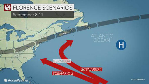
4.45pm (11.45am AST): Two scenarios possible, but both hit Bermuda
In Scenario 1, Florence may track more to the north than west, keeping it east of Bermuda and over the open waters of the central Atlantic next weekend and into the following week.
Rough seas could still pound Bermuda in this scenario.
Florence Florence may be able to curve northward then northeastward out to sea with impacts limited to an indirect nature in the US
In Scenario 2, if the high pressure area remains strong, then Florence may complete a 3,500-mile journey over the Atlantic and be guided right into the US. East Coast somewhere from the Carolinas to southern New England sometime during Wednesday or Thursday of next week.
Regardless which scenario manifests, Bermuda may be in the direct path of the storm, even if the storm begins to curve.
3.50pm (10.50am AST) update: How rare is a strike on the US based on Florence's current position?
From a probability standpoint, it is extremely rare for a hurricane to make landfall along the Carolina coast based on Florence's position as of Thursday, according to data compiled by The Florida State University.
Accuweather reported that most hurricanes that do strike the East Coast are actually farther south in the Atlantic at this point.
The majority of hurricanes passing over the part of the Atlantic where Florence was on Thursday morning do not make landfall in the US.
However, since the weather pattern that may evolve next week over the western Atlantic to the East Coast is unusual for mid-September, we may be in uncharted territory.
All possibilities need to be considered at this point.
No Comments For This Post, Be first to write a Comment.
Most viewed from International
.jpg)


.jpg)


Most viewed from World

.jpg)


.jpg)

Todays Epaper

English Weekly


AIMIM News


Owaisi Begins Election Campaign in Hyderabad
Apr 13, 2024

Bring back Indian workers in Israel: Owaisi
Apr 13, 2024


Latest Urdu News
Most Viewed
May 26, 2020
Do you think Ruturaj Gaikwad would be a good captain for Chennai Super Kings?
Latest Videos View All


Like Us
Home
About Us
Advertise With Us
All Polls
Epaper Archives
Privacy Policy
Contact Us
Download Etemaad App
© 2024 Etemaad Daily News, All Rights Reserved.